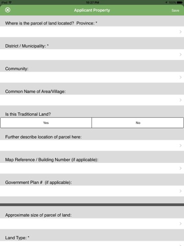
ParcelEye™ organizes informal and customary land rights information in a way that also allows for easy transfer of that information into formal land registration systems. ParcelEye™ is capable of collecting pertinent land tenure information from clients as well as testimony from neighbors who share a boundary with the client’s land. ParcelEye™ is deployed by Medeem in its ParcelCert™ land rights documentation program to capture and digitally store land tenure data and photographs of each client along with their relevant evidentiary documentation. ParcelEye™ data works in a disconnected environment subsequently synced to a cloud-based data center to insure the client’s property and survey data is maintained securely and protected against loss. The ParcelEye™ database is backed-up regularly and secured by iOS level security, password protection, intrusion prevention and encrypted for database security. ParcelEye™ data and records can be easily sorted and searched in list, map, PDF or excel view. Data feeds include: Excel, XML, SON, ATOM, RSS, PDF, MS-ACCESS and SQL Server.
Key Features:
• Customized to meet the government and/or customary land information or registration requirements in each country of operation
• Step by step organization allows for easy and rapid training of field staff
• Organizes land tenure data collection process into segments, allowing for increased productivity and field efficiency.
• “Skip logic” built into the design to streamline and customize the interview process based on client responses.
• Format aligns with most official land registration data collection elements to assure utility of the data in more formal environments should that be desired by the client or land authority.
• Elements of ParcelEye™ are constructed to make it easy for clients of all educational levels to understand the questions and, as a result, produce more accurate and useful information.
• ParcelEye™ provides a firm foundation for data gathering when it comes to basic land tenure/land rights information, and the platform allows for easy migration to more sophisticated uses should the need arise.


